Snake River Canyon cuts through the high desert of southern Idaho like the earth simply cracked open. Standing on the rim in Twin Falls, you look down 500 feet to a ribbon of blue-green water that carved this landscape over millions of years. The scale is hard to process until you're there, wind pushing against your chest, watching a BASE jumper step off the Perrine Bridge and disappear into the void below.
This is not a place you visit quickly. The canyon stretches for miles, and every bend reveals something different — a hidden waterfall, a trail that drops to the river's edge, a viewpoint that makes you stop talking mid-sentence.
Here's everything you need to know before you go.
How Snake River Canyon Formed
The canyon you see today is the product of two geological forces working on vastly different timescales.
The first was volcanic. Between 8 and 10 million years ago, massive basalt lava flows spread across the Snake River Plain, building up hundreds of feet of hard volcanic rock in layers. This created the flat, high-desert plateau that defines southern Idaho's landscape.
The second force was water — and it worked fast by geological standards. During the last Ice Age, roughly 14,500 years ago, a series of catastrophic floods known as the Bonneville Flood carved through the basalt in a matter of days. When ancient Lake Bonneville (the predecessor to today's Great Salt Lake) breached its natural dam at Red Rock Pass near present-day Pocatello, an estimated 33 million cubic feet of water per second rushed down the Snake River drainage. For context, that flow rate rivals the largest flood events ever documented on Earth.
The result was instant canyon. The floodwaters stripped away basalt layers, exposed older rock formations, and carved the 500-foot-deep gorge that runs through Twin Falls today. The Snake River then settled into its current course at the canyon floor, continuing to shape the walls through slower, steady erosion.
You can see the evidence everywhere — the columnar basalt formations along the canyon walls, the layered rock faces showing distinct lava flow events, and the alcoves where softer rock eroded faster than the surrounding basalt. The geology tells the story if you know where to look.
Perrine Bridge
The I.B. Perrine Bridge is the centerpiece of the canyon experience in Twin Falls. Spanning 1,500 feet across the canyon at a height of 486 feet above the Snake River, it's both a functional highway bridge (carrying US-93) and one of the most unusual recreation sites in the American West.
The Only Year-Round Legal BASE Jumping Bridge in the US
What makes Perrine Bridge globally famous isn't its engineering — it's the people jumping off it. Twin Falls is the only place in the United States where BASE jumping is legal year-round without a permit. On any given day, especially in warmer months, you can watch jumpers walk to the pedestrian railing, check the wind, and leap.
The jumping culture here is organized and safety-conscious. Experienced jumpers mentor newcomers. The Twin Falls County Sheriff's office maintains a relationship with the jumping community rather than opposing it. Tandem jumps are available for first-timers through local outfitters — a 486-foot freefall that takes about four seconds before the canopy opens.
The north side of the bridge has a designated viewing area where you can watch jumpers prepare and launch. Mornings tend to be calmer wind-wise, and weekends draw bigger crowds of both jumpers and spectators.
Visitor Center and Canyon Rim
The Visitor Center sits on the north side of the bridge and serves as a solid starting point for any canyon exploration. Inside, you'll find maps, historical exhibits, and information about local trails and attractions. The staff can point you toward current conditions on trails and let you know about any seasonal closures.
The paved path along the canyon rim near the visitor center gives you immediate access to some of the best overlook points without committing to a full hike. It's wheelchair accessible and connects to longer trail systems if you want to keep going.
The Evel Knievel Jump Site
On September 8, 1974, Evel Knievel attempted to jump the Snake River Canyon in a steam-powered rocket called the Skycycle X-2. The event drew 35,000 spectators to the canyon rim and millions more on closed-circuit television. It was one of the most-hyped stunts of the decade.
The jump failed. A drogue parachute deployed prematurely at launch, and the rocket drifted down into the canyon, landing near the river's edge. Knievel survived with minor injuries.
The launch ramp is still visible on the south rim of the canyon, about a mile and a half southeast of the Perrine Bridge. The site sits on private land, but you can see the ramp remnants clearly from several viewpoints. A small monument and interpretive signs mark the general area.
Whether you consider it triumph or failure depends on your perspective. Knievel attempted something nobody had done — and the ramp sitting on that canyon rim, over 50 years later, remains one of the most recognizable landmarks in Twin Falls. It's worth the stop, even if just for the story.
Hiking Trails
Snake River Canyon offers some of the best accessible hiking in southern Idaho. The rim trails are mostly flat and easy; the canyon trails that descend to the water demand more effort but deliver bigger rewards.
Centennial Waterfront Trail
This is the main arterial trail along the Snake River, running from Centennial Waterfront Park downstream toward Shoshone Falls. The entire path is paved and flat, making it accessible for strollers, bikes, and wheelchairs. It follows the river closely, passing through cottonwood groves and offering frequent water views.
The trail connects several parks and access points, so you can walk as much or as little as you want. Early morning is the best time — the canyon catches golden light, and you'll often spot great blue herons, osprey, and the occasional bald eagle hunting along the river.
Canyon Rim Trail
The Canyon Rim Trail runs along the north edge of the canyon, connecting the Perrine Bridge area to several parks and viewpoints. Much of it is paved or well-maintained gravel. The views are consistently impressive — you're walking along the edge of a 500-foot drop with the river visible below.
Several spur trails branch off the main rim path and descend partway into the canyon. These are steeper and less maintained but offer perspectives you can't get from the rim. The section between the visitor center and Centennial Park is the most popular and well-marked.
Pillar Falls Trail
This is the hike that gets you down to the river. The trail drops from the canyon rim to the base of Pillar Falls, a striking formation where basalt columns create a series of cascades across the Snake River. The descent is steep and rocky — wear proper footwear and bring trekking poles if you have them.
At the bottom, you can wade across shallow sections of the river to reach the rock formations (water levels permitting — check conditions before you go). The basalt pillars rising from the water make it one of the most photographed spots in the canyon. In summer, people swim here, though the current can be stronger than it appears.
Allow 2-3 hours round trip. Start early in summer to avoid the afternoon heat reflecting off the canyon walls.
Mogensen Trail
A less-trafficked option that descends to the canyon floor near the Snake River. The trail is well-defined but steeper than it looks from the top. It connects to a network of informal paths along the river that experienced hikers use to access fishing spots and swimming holes.
This is a good choice if you want river access without the crowds that Pillar Falls attracts on summer weekends.
Hidden Gems Worth the Detour
The main canyon attractions draw the crowds, but some of the best experiences in the area require a short drive and a willingness to explore.
Box Canyon State Park
Location: 15 minutes west of Twin Falls, near Wendell
Box Canyon is a spring-fed canyon where 180,000 gallons of water per minute flow from the canyon walls through a massive natural spring. The water emerges from the volcanic rock at a consistent temperature year-round, feeding a crystal-clear stream that flows to the Snake River.
The short trail descends to the canyon floor, where the scale of the spring becomes apparent. The water volume is staggering — it's the 11th largest spring in the United States. In winter, the consistent water temperature keeps the canyon green while the surrounding landscape is brown and frozen.
There's a small parking area and a modest day-use fee. It rarely feels crowded, even in summer.
Thousand Springs
Location: Along US-30, west of Twin Falls (Hagerman Valley)
Thousand Springs is exactly what it sounds like — hundreds of springs emerging from the canyon walls along a stretch of the Snake River near Hagerman. Water that entered the ground as snowmelt in the mountains north of the Snake River Plain travels underground through porous basalt for decades before emerging here, sometimes hundreds of feet above the river.
The springs cascade down the canyon walls in ribbons and curtains of water. The best views are from the road (US-30) or from the river itself if you're kayaking. Thousand Springs State Park has several units with different access points and overlooks.
This area was historically significant to the Shoshone-Bannock people and later to Oregon Trail emigrants who recorded the springs in their journals. Some of the spring water now feeds fish hatcheries and aquaculture operations in the Hagerman Valley — you'll see the green ponds along the highway.
Balanced Rock
Location: 20 minutes southwest of Twin Falls, near Castleford
A 40-foot-tall mushroom-shaped rock formation balanced on a pedestal just 3 feet by 17 inches. It looks like it should have fallen over centuries ago. The formation is the result of wind erosion wearing away the softer base rock faster than the harder cap rock above.
A short trail from the parking area leads to the base of the rock. It's a quick stop — 30 minutes round trip — but genuinely striking in person. The surrounding landscape of sage and canyon adds to the feeling that you've wandered into a geological curiosity cabinet.
Best Viewpoints
From the North Rim
- Perrine Bridge overlook — The classic view. Walk to the middle of the bridge for the vertigo-inducing straight-down perspective, or stay at the north viewing area for the wider panorama.
- Canyon Rim Trail overlooks — Multiple pull-off points along the trail east of the bridge, each offering a slightly different angle on the canyon.
- Centennial Park — A bit further east on the rim trail, with picnic facilities and a quieter atmosphere.
From the South Rim
- Evel Knievel jump site area — Wide-angle view across the canyon with the Perrine Bridge in the distance. Best in late afternoon when the sun lights up the north canyon wall.
- Snake River Canyon overlook (near the College of Southern Idaho) — An easily accessible viewpoint near the campus with parking and paved paths.
From the Canyon Floor
- Pillar Falls — The view looking up from the base of the canyon is completely different from anything on the rim. The scale of the walls becomes real when you're standing at the bottom.
- Centennial Waterfront — River-level views with the canyon walls rising on both sides. Best at dawn or dusk when light paints the basalt.
Sunrise and Sunset
For sunrise, position yourself on the north rim looking east — the first light hits the south canyon wall and turns the basalt orange. For sunset, the south rim looking west gives you the best color as light plays across the river and the north-facing cliffs.
Water Access and River Activities
The Snake River through the canyon is more accessible than you might expect, though it demands respect.
Kayaking and Stand-Up Paddleboarding
Several outfitters in Twin Falls offer kayak and SUP rentals for the calmer stretches of the river. The section upstream of Shoshone Falls and certain stretches near Centennial Waterfront Park are popular for flatwater paddling. The water is cold year-round — the upstream springs keep it cool even in August.
Guided trips are available and recommended for first-timers. The river has currents and hydraulics that aren't obvious from shore.
Fishing
The Snake River through the canyon supports trout (rainbow and brown), smallmouth bass, sturgeon (catch and release), and whitefish. Access points along the Centennial Trail and Mogensen Trail put you at river level. An Idaho fishing license is required.
The canyon provides shelter from wind, making it fishable on days when the open plain above is getting hammered. Early morning and evening are the most productive times.
Swimming
Swimming happens at Pillar Falls, Centennial Waterfront, and several informal access points. There are no lifeguards anywhere in the canyon. The water is cold (50-60 degrees even in summer), currents are unpredictable, and submerged rocks are common. Wade carefully before committing to deeper water, and never swim alone.
Safety and Practical Information
Trail Safety
- Stay on marked trails near the canyon rim. The basalt edges can be undercut and unstable. People have died falling from the rim.
- Bring water. Southern Idaho is high desert. Summer temperatures regularly hit 95-100 degrees, and there's little shade on rim trails.
- Watch for rattlesnakes. They're present in the canyon, particularly in warmer months. Stay on trails, watch where you step, and give them space if you encounter one.
- Cell service is inconsistent in the canyon itself. Tell someone your plans before descending.
River Safety
- Check water levels and flow rates before any water activity. The Bureau of Reclamation controls upstream releases, and conditions can change.
- Cold water is the primary hazard. Even strong swimmers can be incapacitated by cold shock in 55-degree water.
- Wear a life jacket for any river activity. The current is stronger than it looks.
Getting There
Snake River Canyon runs through Twin Falls, Idaho. The Perrine Bridge and Visitor Center are accessible directly from US-93. Most trailheads are within 10-15 minutes of downtown Twin Falls. Box Canyon and Thousand Springs are 15-30 minutes west along US-30.
Free parking is available at most trailheads and viewpoints. The Visitor Center has restrooms and is open year-round.
When to Visit
Spring (April-May): Wildflowers on the rim, higher water levels in the river and at the falls. Mornings can be cool. The canyon is green and lush before summer dries things out.
Summer (June-August): Peak season. Best for water activities, BASE jumping spectating, and long evening hikes. Midday heat can be intense — plan rim hikes for early morning or late afternoon.
Fall (September-October): The canyon's cottonwoods turn gold against the dark basalt. Crowds thin out. Temperatures are comfortable for hiking all day. This is arguably the best time for photography.
Winter (November-March): Quieter, but the canyon is open year-round. Rim trails may be icy. The river stays flowing, and Box Canyon's springs are particularly striking against the winter landscape. BASE jumping continues, weather permitting.
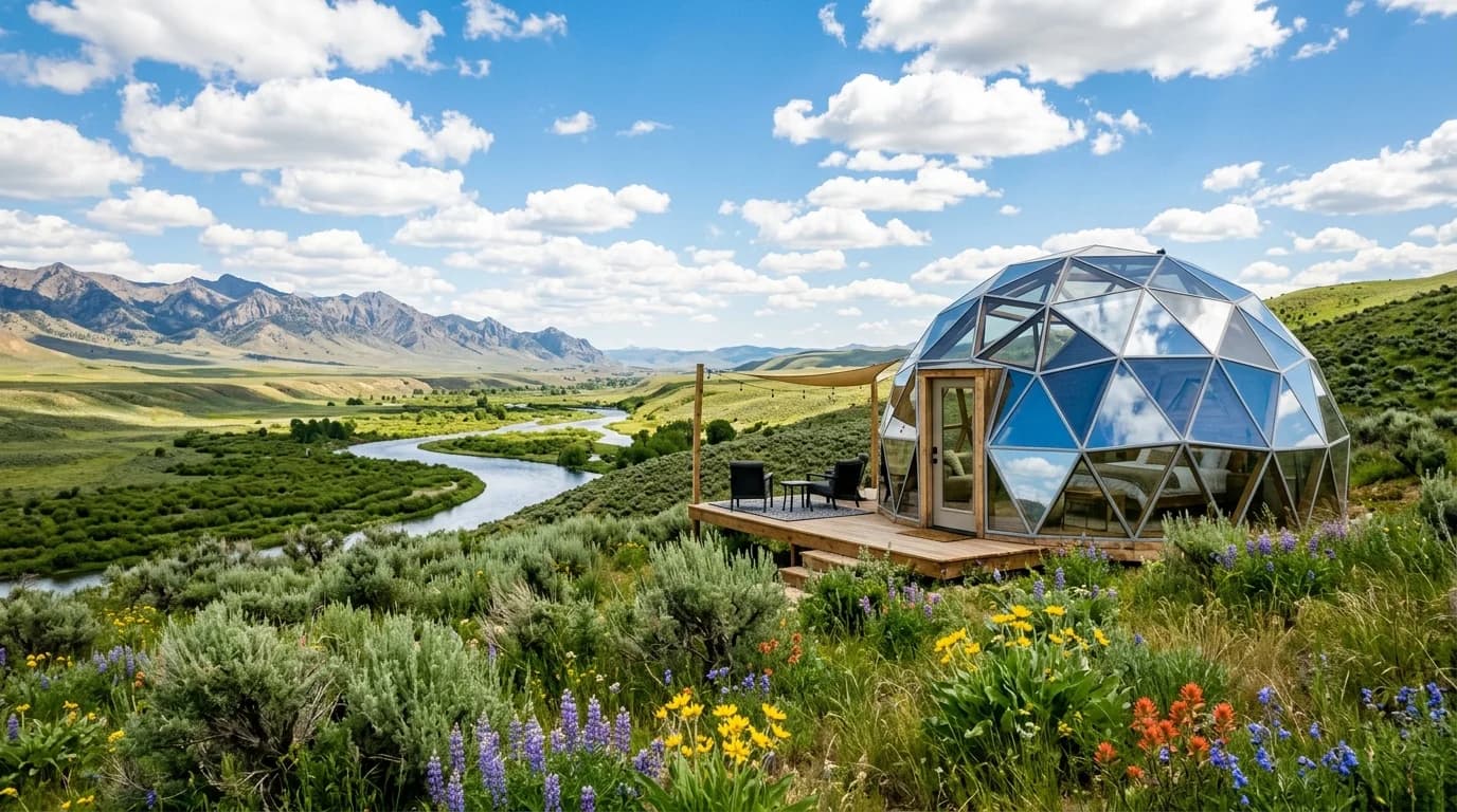
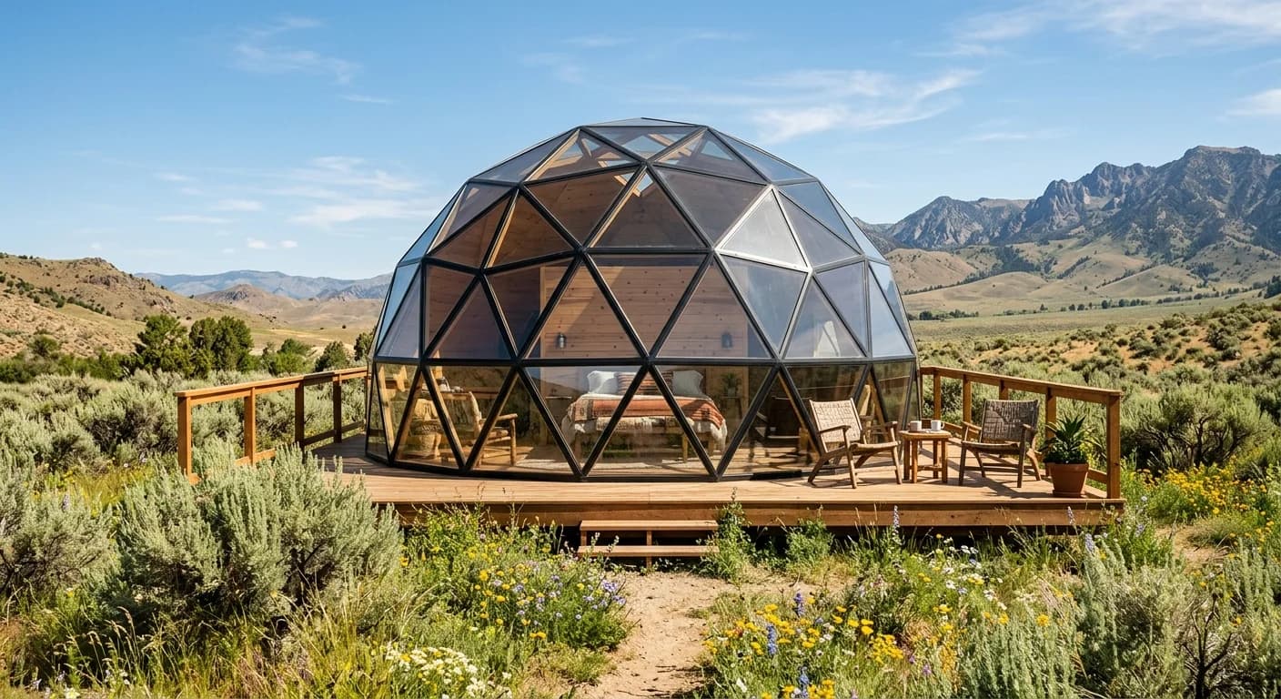
Your Canyon Basecamp
Snake River Canyon is the kind of place that rewards repeat visits. The first time, you'll hit the Perrine Bridge and the main overlooks. The second time, you'll hike down to Pillar Falls. By the third visit, you'll have your own favorite viewpoint and a list of trails you still want to explore.
LuxeDen Resorts is located minutes from the canyon rim, making it an ideal basecamp for extended canyon exploration. Wake up in a geodesic dome, watch the sunrise over the high desert, and be standing on the canyon rim before most people have finished breakfast.
Related Guides
- Shoshone Falls: Complete Visitor's Guide — hours, admission, After Dark light show, and the best time to see peak flow
- BASE Jumping at Perrine Bridge — watch or book a tandem jump at the canyon's most famous bridge
- Outdoor Adventures Near Twin Falls — the full range of activities beyond the canyon
- 3-Day Idaho Vacation Itinerary — a day-by-day plan covering the canyon highlights and more
- Stargazing and Dark Skies in Idaho — the canyon after dark is a different experience entirely
Join our VIP list for early access when we open Summer 2027. The canyon has been here for 14,500 years — it'll wait for you.